Bass Camp and Trail

Bass Cable Car in Service.

William Wallace Bass moved to the Grand Canyon in 1883. He moved from the East for health reasons and rumors of Gold brought him into the Grand Canyon. When the rumors turned out to be false he turned to the tourist industry. He set up a camp at Havasupai Point on the rim of the Grand Canyon. This camp was accessible via a road Bass built from Ashfork. During its 36-year history several thousand visitors registered there including such names as George Wharton James, writer Zane Grey, artist Thomas Moran, naturalist John Muir, industrialist Henry Ford and Army Lieutenant Joseph Ives.


From the Bass Camp on the rim, Bass constructed a trail and led tourists down to the Colorado River at the bottom of the Grand Canyon. Guests were able to cross the river in a boat until 1908. Then in 1908 Bass constructed a cable car across the river and attached a to ferry people, supplies, and animals across the river.

The Bass Tent Camp up Shinumo Creek

Once across the river, guests were led up and over a saddle into the Shinumo Creek drainage. A couple of miles up Shinumo Creek, Bass built a tent camp complete with an orchard. The camp in Shinumo was nestled in an incredibly beautiful location with a nice stream and beautiful trees. The guests who were able to experience the Grand Canyon with Bass were extremely lucky.


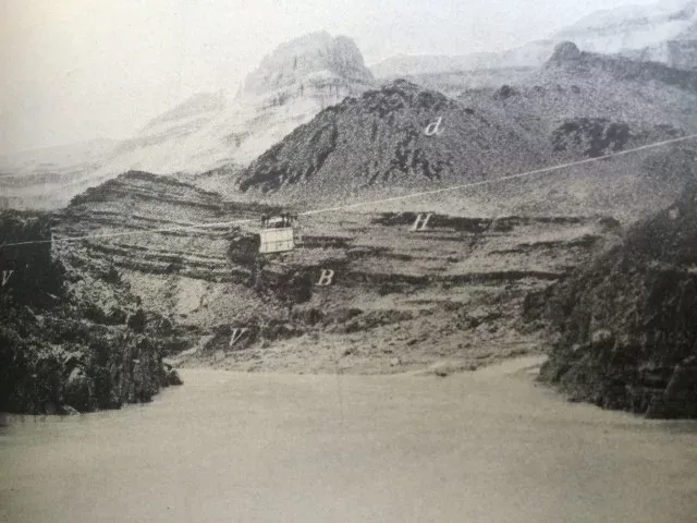
Today Bass’s broken down cable car is rotting away at mile 108. This part of the canyon has always been one of my favorite parts. Shinumo Creek is always a cool and relaxing stop. In addition, the rapids of Crystal, Horn Creek, Hermit, Granite, and Hance are now behind you. Upon the rim, the lone “lollipop” tree up on the Powell Plateau is in view.


The hike up to Base Camp is also one of my favorites. The views from the saddle up the river are incredible, and hiking down along Shinumo Creek is heavenly. The ancestral Puebloans must have also like this area because there are a huge number of artifacts and structures that are still visible.

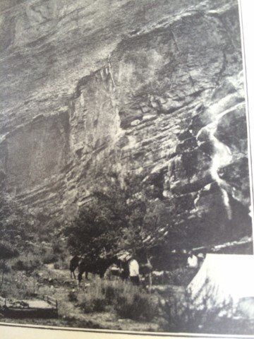
I have hiked the trail many times and when I get up to the abandoned camp I always think of the effort taken to carry things in and out of the Grand Canyon. At the camp, many artifacts are still present including an Iron stove and lots of coffee pots a

More About the Bass Camp and Trail

Sandy beach inside a cavern overlooks a river, with red rock canyon walls and a blue sky.
February 15, 2026
The Colorado River below Glen Canyon Dam flows through the lower reaches of Glen Canyon on its way to Lees Ferry , forming one of the most studied and discussed stretches of river in the American Southwest. Released from the base of the dam, the water is typically clear and tightly controlled. In recent years, however, lower water levels in Lake Powell have caused releases to come from shallower depths, warming the river compared to past decades and changing the conditions downstream. This reach is calm and approachable, making it a popular destination for kayaking, rafting, fishing, and flatwater exploration. Visitors often take time to linger along the banks, explore side canyons, and pull over at small beaches and alcoves—experiencing the river at an unhurried pace that encourages observation and learning.  Quick facts about this stretch of river naturally help frame why it matters:
Glen Canyon Dam with bridge and canyon walls under a blue sky. Water flows towards the dam.
February 12, 2026
The Dirty Devil River joins the Colorado River at River Mile 169.5. John Wesley Powell camped at this confluence on July 28, 1869, describing the tributary as extremely muddy and foul-smelling. Jack Sumner later named it the Dirty Devil. The Dirty Devil is formed by the confluence of Muddy Creek and the Fremont River near present-day Hanksville, Utah. The Fremont River originates at Fish Lake and flows along the Waterpocket Fold through Capitol Reef National Park. Muddy Creek drains the San Rafael Swell. Historic Context — Powell’s Expeditions: Powell’s 1869 expedition recorded the Dirty Devil as both a geographic reference and a warning. In his later expeditions of 1871–72, Powell returned with improved boats and a scientific mandate. Tributaries such as the Dirty Devil became fixed reference points for mapping and geologic observation. Powell’s journals note the heavy silt load and poor water quality here, and his party avoided using the Dirty Devil as a water source when possible.
Camping gear on a sandy beach near a red rock wall and river under a cloudy sky.
February 12, 2026
Camping and Dining